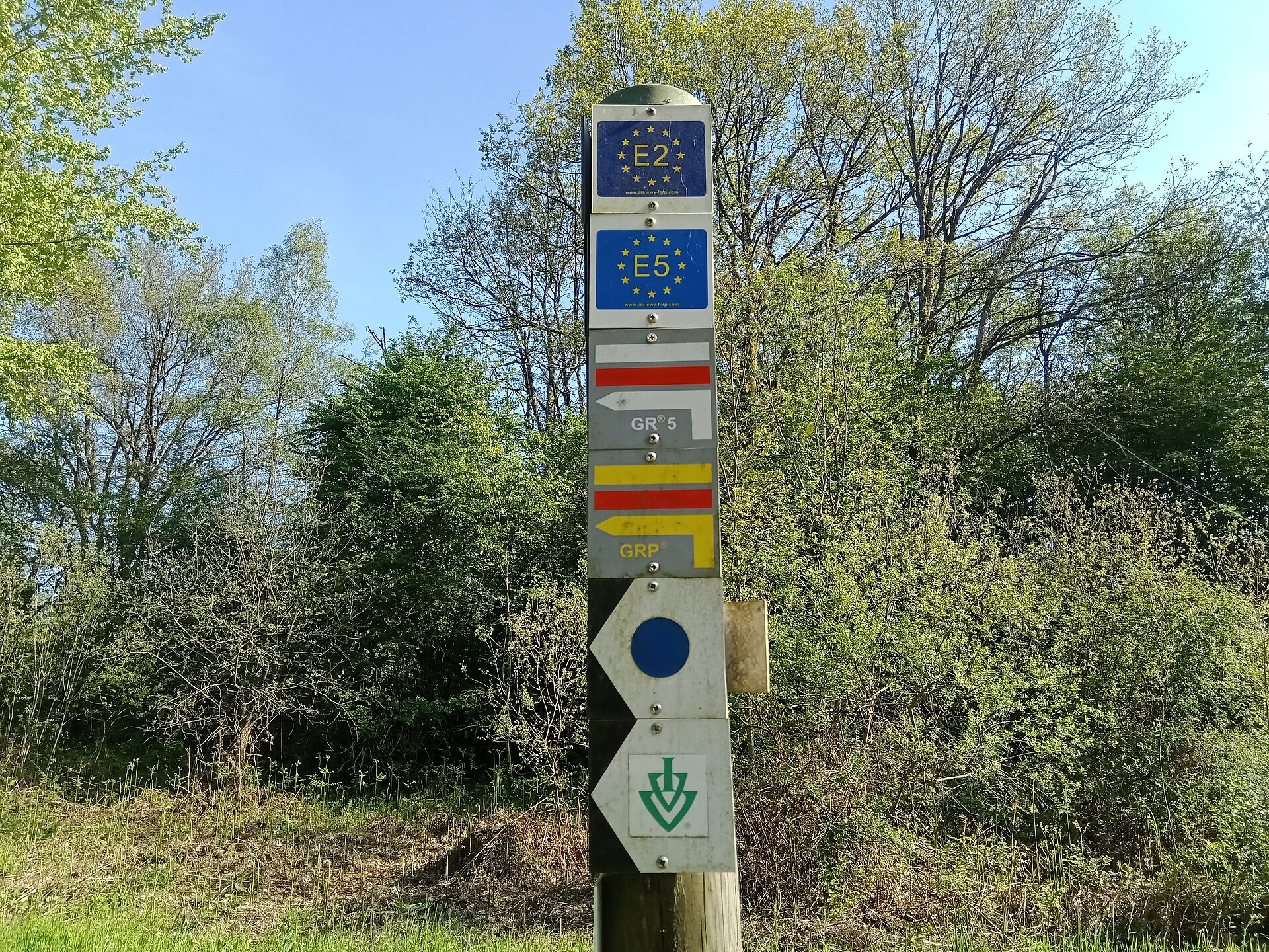
Photo: Rémih · Wikimedia Commons · CC BY-SA 4.0

E5
FRCHATDEThis route is not finished yet Parts of this route are not on the map yet; the app shows where the line stops.
The E5 European long distance path or E5 path is one of the European long-distance paths from the French Atlantic coast in Brittany through Switzerland, Austria and Germany over the Alps to Venice in Italy. It is waymarked over the whole 3200 km distance. The heaviest used section is the last part, which crosses Europe’s highest mountains from Lake Constance to Italy. Even this part does not require climbing experience.
Stages
| 1 | Pointe du Raz → Penharn | 17.5 km | ↗ 550 m |
| 2 | Penharn → Kervoazec | 19.1 km | ↗ 596 m |
| 3 | Kervoazec → Le Ris | 19.3 km | ↗ 355 m |
| 4 | Le Ris → Chemin des Douaniers, Pentrez | 18.6 km | ↗ 247 m |
| 5 | Chemin des Douaniers, Pentrez → Marros | 25.3 km | ↗ 536 m |
| 6 | Marros → Chemin des Douaniers, Le Faou | 12 km | ↗ 259 m |
| 7 | Chemin des Douaniers, Le Faou → Croas ar Go | 15.8 km | ↗ 386 m |
| 8 | Croas ar Go → Gîte d'étape Communal | 16.5 km | ↗ 284 m |
| 9 | Gîte d'étape Communal → Kervéguénet | 20.2 km | ↗ 309 m |
| 10 | Kervéguénet → Pont Mikael | 21.4 km | ↗ 246 m |
| 11 | Pont Mikael → Toull Bléï | 18.2 km | ↗ 333 m |
| 12 | Toull Bléï → Carhaix | 19.5 km | ↗ 237 m |
| 13 | Carhaix → Glomel | 20.7 km | ↗ 218 m |
| 14 | Glomel → Kermarc'h | 15.4 km | ↗ 197 m |
| 15 | Kermarc'h → Liscuis | 18.5 km | ↗ 253 m |
| 16 | Liscuis → Mûr-de-Bretagne | 19.4 km | ↗ 390 m |
| 17 | Mûr-de-Bretagne → De Lanester au Lac de Guerlédan, Saint-Gérand | 42.2 km | ↗ 484 m |
| 18 | De Lanester au Lac de Guerlédan, Saint-Gérand → Josselin | 44.3 km | ↗ 261 m |
| 19 | Josselin → Tréhorenteuc | 50.6 km | ↗ 419 m |
| 20 | Tréhorenteuc → Bonamenay | 41.2 km | ↗ 466 m |
| 21 | Bonamenay → Le Perray | 6.8 km | ↗ 34 m |
| 22 | Le Perray → Étang de Trémelin | 8.6 km | ↗ 88 m |
| 23 | Étang de Trémelin → Rophémel | 42.9 km | ↗ 317 m |
| 24 | Rophémel → Tressaint | 23 km | ↗ 151 m |
| 25 | Tressaint → Port Saint-Hubert | 21.6 km | ↗ 375 m |
| 26 | Port Saint-Hubert → La Rance | 21.9 km | ↗ 252 m |
| 27 | La Rance → Chemin des Douaniers, Saint-Méloir-des-Ondes | 52 km | ↗ 797 m |
| 28 | Chemin des Douaniers, Saint-Méloir-des-Ondes → Chemin des Douaniers, Mont Saint-Michel | 47.7 km | ↗ 231 m |
| 29 | Chemin des Douaniers, Mont Saint-Michel → Avranches | 27 km | ↗ 5 m |
| 30 | Avranches → Le Petit-Celland | 20 km | ↗ 513 m |
| 31 | Le Petit-Celland → Saint-Pois | 22 km | ↗ 399 m |
| 32 | Saint-Pois → Gîte d'Etape | 21.6 km | ↗ 572 m |
| 33 | Gîte d'Etape → Rancoudray | 15.3 km | ↗ 343 m |
| 34 | Rancoudray → L'Être Chapron | 17.8 km | ↗ 205 m |
| 35 | L'Être Chapron → Beauvent | 16.3 km | ↗ 284 m |
| 36 | Beauvent → Bagnoles-de-l'Orne | 17.2 km | ↗ 93 m |
| 37 | Bagnoles-de-l'Orne → La Lambercière | 20.3 km | ↗ 261 m |
| 38 | La Lambercière → L'Orée-d'Ecouves | 24.7 km | ↗ 302 m |
| 39 | L'Orée-d'Ecouves → Alençon | 21.1 km | ↗ 177 m |
| 40 | Alençon → Louzes | 22.1 km | ↗ 353 m |
| 41 | Louzes → Le Moulin Butin | 18.6 km | ↗ 236 m |
| 42 | Le Moulin Butin → Colonard-Corubert | 18.6 km | ↗ 339 m |
| 43 | Colonard-Corubert → La Chapelle-Montligeon | 16.3 km | ↗ 255 m |
| 44 | La Chapelle-Montligeon → Malétable | 17.5 km | ↗ 324 m |
| 45 | Malétable → Le Bois Girard | 20.1 km | ↗ 182 m |
| 46 | Le Bois Girard → Verneuil | 22.5 km | ↗ 106 m |
| 47 | Verneuil → Dampierre-sur-Avre | 22.8 km | ↗ 152 m |
| 48 | Dampierre-sur-Avre → Muzy | 22.9 km | ↗ 215 m |
| 49 | Muzy → Anet | 22.5 km | ↗ 262 m |
| 50 | Anet → Saint-Lubin-de-la-Haye | 19.8 km | ↗ 161 m |
| 51 | Saint-Lubin-de-la-Haye → Orgerus | 17.6 km | ↗ 113 m |
| 52 | Orgerus → Montfort-l'Amaury | 22.2 km | ↗ 276 m |
| 53 | Montfort-l'Amaury → Les Clayes-sous-Bois | 18.7 km | ↗ 223 m |
| 54 | Les Clayes-sous-Bois → Versailles | 20.1 km | ↗ 254 m |
| 55 | Versailles → Paris | 30.4 km | ↗ 303 m |
| 56 | Paris → Saint-Maurice | 10.6 km | ↗ 51 m |
| 57 | Saint-Maurice → Nogent-sur-Marne | 20.5 km | ↗ 86 m |
| 58 | Nogent-sur-Marne → Montfermeil | 16.8 km | ↗ 152 m |
| 59 | Montfermeil → Carnetin | 16.7 km | ↗ 115 m |
| 60 | Carnetin → Meaux | 20.4 km | ↗ 69 m |
| 61 | Meaux → Mortcerf | 30.1 km | ↗ 439 m |
| 62 | Mortcerf → Verneuil-l'Étang | 23.9 km | ↗ 52 m |
| 63 | Verneuil-l'Étang → Moisenay | 25.2 km | ↗ 107 m |
| 64 | Moisenay → Chartrettes | 20 km | ↗ 138 m |
| 65 | Chartrettes → Thomery | 18.6 km | ↗ 253 m |
| 66 | Thomery → Montereau-Fault-Yonne | 19.7 km | ↗ 151 m |
| 67 | Montereau-Fault-Yonne → Villeblevin | 22.3 km | ↗ 213 m |
| 68 | Villeblevin → Gisy-les-Nobles | 20.1 km | ↗ 226 m |
| 69 | Gisy-les-Nobles → Thorigny-sur-Oreuse | 19.6 km | ↗ 299 m |
| 70 | Thorigny-sur-Oreuse → Molinons | 18.5 km | ↗ 233 m |
| 71 | Molinons → Aix-en-Othe | 20.4 km | ↗ 226 m |
| 72 | Aix-en-Othe → Vauchassis | 21.3 km | ↗ 317 m |
| 73 | Vauchassis → Sommeval | 14.3 km | ↗ 241 m |
| 74 | Sommeval → Les Loges-Margueron | 24 km | ↗ 134 m |
| 75 | Les Loges-Margueron → Rumilly-lès-Vaudes | 16.2 km | ↗ 75 m |
| 76 | Rumilly-lès-Vaudes → Bar-sur-Seine | 18.9 km | ↗ 89 m |
| 77 | Bar-sur-Seine → Mussy-sur-Seine | 30.5 km | ↗ 461 m |
| 78 | Mussy-sur-Seine → Via Francigena France 04, Clairvaux | 34.8 km | ↗ 452 m |
| 79 | Via Francigena France 04, Clairvaux → Orges | 19.4 km | ↗ 349 m |
| 80 | Orges → Richebourg | 18.5 km | ↗ 177 m |
| 81 | Richebourg → Faverolles | 20.9 km | ↗ 190 m |
| 82 | Faverolles → Perrancey-les-Vieux-Moulins | 15.9 km | ↗ 143 m |
| 83 | Perrancey-les-Vieux-Moulins → Lecey | 20.4 km | ↗ 312 m |
| 84 | Lecey → Varennes-sur-Amance | 23 km | ↗ 368 m |
| 85 | Varennes-sur-Amance → Bourbonne-les-Bains | 21.3 km | ↗ 307 m |
| 86 | Bourbonne-les-Bains → Aureil-Maison | 16.4 km | ↗ 261 m |
| 87 | Aureil-Maison → Saint-Baslemont | 21.8 km | ↗ 140 m |
| 88 | Saint-Baslemont → Clairefontaine | 21.4 km | ↗ 264 m |
| 89 | Clairefontaine → Les Forges d'Uzemain | 19.4 km | ↗ 301 m |
| 90 | Les Forges d'Uzemain → Le Pranzieux | 19.1 km | ↗ 442 m |
| 91 | Le Pranzieux → Remiremont | 13.8 km | ↗ 204 m |
| 92 | Remiremont → La Rosière | 16.9 km | ↗ 815 m |
| 93 | La Rosière → Château-Lambert | 15.3 km | ↗ 472 m |
| 94 | Château-Lambert → Des Vosges aux Pyrénées 01, Ballon d'Alsace | 16.5 km | ↗ 1,029 m |
| 95 | Des Vosges aux Pyrénées 01, Ballon d'Alsace → Lachapelle-sous-Chaux | 19.5 km | ↗ 174 m |
| 96 | Lachapelle-sous-Chaux → Danjoutin | 18 km | ↗ 209 m |
| 97 | Danjoutin → Fesches-le-Châtel | 17.2 km | ↗ 128 m |
| 98 | Fesches-le-Châtel → Réchésy via Belfort | 19.8 km | ↗ 343 m |
| 99 | Réchésy via Belfort → Liebsdorf | 13.3 km | ↗ 354 m |
| 100 | Liebsdorf → Lucelle | 9.9 km | ↗ 317 m |
| 101 | Basel → Rheinfelden | 16.2 km | ↗ 52 m |
| 102 | Rheinfelden → Bad Säckingen | 20 km | ↗ 142 m |
| 103 | Bad Säckingen → Schwaderloch | 19.2 km | ↗ 249 m |
| 104 | Schwaderloch → Bad Zurzach | 21 km | ↗ 71 m |
| 105 | Bad Zurzach → Eglisau | 20.8 km | ↗ 91 m |
| 106 | Eglisau → Rheinau | 18.4 km | ↗ 269 m |
| 107 | Rheinau → Langwiesen | 16.2 km | ↗ 202 m |
| 108 | Langwiesen → Stein am Rhein | 19.1 km | ↗ 91 m |
| 109 | Stein am Rhein → Steckborn | 15.2 km | ↗ 444 m |
| 110 | Steckborn → Kreuzlingen | 19.2 km | ↗ 228 m |
| 111 | Kreuzlingen → Egnach | 25.8 km | ↗ 22 m |
| 112 | Egnach → Gaißau | 21.9 km | ↗ 237 m |
| 113 | Gaißau → Seecamping Bregenz | 18 km | ↗ 15 m |
| 114 | Seecamping Bregenz → Alberschwende | 16.6 km | ↗ 605 m |
| 115 | Alberschwende → Lingenau | 11.2 km | ↗ 556 m |
| 116 | Lingenau → Naturpark Nagelfluhkette | 14.8 km | ↗ 618 m |
| 117 | Naturpark Nagelfluhkette → Gündlesscharte | 8 km | ↗ 1,019 m |
| 118 | Gündlesscharte → Gunzesried | 11.8 km | ↗ 594 m |
| 119 | Gunzesried → Oberstdorf | 18.2 km | ↗ 100 m |
| 120 | Oberstdorf → Mädelejoch | 15.1 km | ↗ 1,234 m |
| 121 | Mädelejoch → Obergiblen | 12.6 km | ↗ 296 m |
| 122 | Obergiblen → Memminger Hütte | 14 km | ↗ 1,403 m |
| 123 | Memminger Hütte → Zams | 12.8 km | ↗ 537 m |
| 124 | Zams → Wenns | 13.6 km | ↗ 374 m |
| 125 | Sankt Leonhard im Pitztal → Dreizeiger | 8 km | ↗ 1,261 m |
| 126 | Dreizeiger → Zwieselstein | 13.6 km | ↗ 100 m |
| 127 | Zwieselstein → Timmelsjoch - Passo Rombo | 8.1 km | ↗ 1,041 m |
| 128 | Timmelsjoch - Passo Rombo → Moos in Passeier - Moso in Passiria | 14 km | ↗ 128 m |
| 129 | Moos in Passeier - Moso in Passiria → St. Martin in Passeier - San Martino in Passiria | 13.9 km | ↗ 723 m |
| 130 | St. Martin in Passeier - San Martino in Passiria → Hirzer Hütte | 9.6 km | ↗ 1,407 m |
| 131 | Hirzer Hütte → Meranerhütte - Rifugio Merano | 10.2 km | ↗ 922 m |
| 132 | Meranerhütte - Rifugio Merano → Bolzano - Bozen | 23.2 km | ↗ 346 m |
| 133 | Bolzano → Deutschnofen - Nova Ponente | 15.3 km | ↗ 1,745 m |
| 134 | Deutschnofen - Nova Ponente → Unterradein - Redagno di Sotto | 15.7 km | ↗ 631 m |
| 135 | Unterradein - Redagno di Sotto → Malga Monte Corno - Trudner Horn Alm | 10.4 km | ↗ 872 m |
| 136 | Malga Monte Corno - Trudner Horn Alm → Rifugio Potzmauer | 11.7 km | ↗ 299 m |
| 137 | Rifugio Potzmauer → Segonzano | 17 km | ↗ 519 m |
| 138 | Segonzano → Palai en Bersntol - Palù del Fersina | 13.8 km | ↗ 1,041 m |
| 139 | Palai en Bersntol - Palù del Fersina → Bivacco dell'Amicizia | 10.4 km | ↗ 1,284 m |
| 140 | Bivacco dell'Amicizia → Levico Terme | 13.4 km | ↗ 94 m |
| 141 | Levico Terme → Gionghi | 10.8 km | ↗ 1,068 m |
| 142 | Gionghi → Hotel Forte Cherle | 15.2 km | ↗ 642 m |
| 143 | Hotel Forte Cherle → Sogli Bianchi | 15.8 km | ↗ 1,098 m |
| 144 | Sogli Bianchi → Rifugio Achille Papa | 15.2 km | ↗ 980 m |
| 145 | Rifugio Achille Papa → Rifugio Campogrosso | 11.7 km | ↗ 647 m |
| 146 | Rifugio Campogrosso → Selva di Progno | 12.9 km | ↗ 694 m |
| 147 | Selva di Progno → Tinazzo | 15.3 km | ↗ 1,000 m |
| 148 | Tinazzo → Giare | 16 km | ↗ 635 m |
| 149 | Giare → Verona | 17.9 km | ↗ 276 m |